miércoles, 28 de octubre de 2020

DEPRESSIONS OUTSIDE THE MESETA

What are depressions?

Depressions are large, flat areas of land that are lower than the surrounding area. In Spain, there are two main depressions, the Ebro Depression and the Guadalquivir Depression. Both contain long rivers which flow to the coast. SPANISH: Las depresiones son grandes y llanas zonas de tierra que son más bajar que la zona por la que está rodeada. En España hay dos depresiones, la Depresión del Ebro y la Depresión del Guadalquivir. Ambas contienen largos ríos que desembocan en la costa.

What is the Ebro Depression like?

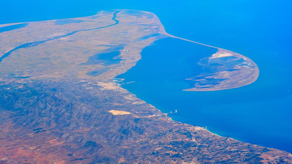
The Ebro Depression is located between the Pyrenees and the Iberian System. It occupies land in four autonomous communities. The average altitude is 200 metres. At the mouth of the Ebro there is an area of low wetlands called the Ebro Delta. The land is very fertile in this area. It receives deposits of materials collected along the course of the river, from its source in Cantabria to the Mediterranean coast. It forms part of the Ebro Delta National Park. SPANISH: La Depresión del Ebro se encuentra localizada entre los Pirineos y el Sistema Ibérico. Ocupa cuatro comunidades autónomas. Su altitud media es de 200 metros. En la desembocadura del Río Ebro hay una zona de humedales bajos llamada Delta del Ebro. La tierra es muy fértil en esta zona. Recibe depósitos de materiales recogidos a lo largo del curso del río, desde su nacimiento en Cantabria hasta la costa mediterránea. Forma parte del Parque Nacional del Delta del Ebro.

Ebro Delta

What is the Guadalquivir Depression like?

The Guadalquivir Depression runs from east to west through Andalucía, between the Sierra Morena and the Subbaetic Range. The average altitude of land in the Guadalquivir Depression is 100 metres and it is the lowest on the peninsula. The source of the Guadalquivir River is in the Cazorla Mountains. The Guadalquivir Depression widens as the river reaches the ocean. In the lowlying coastal area around the mouth of the river, the tide floods the lands. The salt marshes that are formed by sea water are extremely fertile and are part of Doñana National Park. SPANISH: La Depresión del Guadalquivir reocorre de este a oeste por Andalucía, entre Sierra Morena y la Cordillera Subbética. La altitud media del terreno es de 100 metros y es la más baja de la península. El nacimiento del río Guadalquivir está en la Sierra de Cazorla. La depresión del Guadalquivir se ensancha a medida que el río llega al océano. En la zona costera baja alrededor de la desembocadura del río, la marea inunda las tierras. Las marismas que forman el agua del mar son sumamente fértiles y forman parte del Parque Nacional de Doñana

Guadalquivir Depression

Guadalquivir Depression


Cazorla


TIME TO PLAY


martes, 27 de octubre de 2020

WEATHER AND CLIMATE

 What's the difference between weather and climate?

The weather is the atmospheric conditions in a specific place at a moment in time. The weather changes frequently . Climate is the atmospheric conditions of an area during a long period of time. SPANISH: El tiempo atmosférico son las condiciones atmosféricas de un lugar específico en un momento determinado. El tiempo atmosférico cambia frecuentemente. El Clima son las condiciones atmosféricas de una zona durante un largo periodo de tiempo.


Weather


Climate during a year


TIEMPO ATMOSFÉRICO Y CLIMA

• The temperature of the atmosphere is measured in degrees Celsius (ºC). SPANISH: La temperatura de la atmósfera se mide en grados Celsius o grados centógrados (ºC).

Thermometer

• The speed of wind is measured in kilometres per hour. We use the cardinal points to talk about its direction. SPANISH: La velocidad del viento es medida en kilómetros por hora Usamos los puntos cardinales (norte, sur, este y oeste para conocer la dirección).

Anemometer


• Precipitation is measured in millimetres (mm). SPANISH: Las precipitaciones son medidas en milímetros.

Rain gauge


• Humidity is the amount of water vapour in the air. It’s measured with a hygrometer. SPANISH: La humedad es la cantidad de vapor de agua que hay en el aire. Se mide con un higrómetro.

Hygrometer

INSTRUMENTOS METEOROLÓGICOS


What are climate zones?

Climate Zones


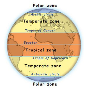
The climate on the Earth can be divided into three main zones: SPANISH: El clima de la Tierra se puede dividir en tres zonas principales.

Climate zones (Tropical, temperate and polar zones) during a year


• The tropical zone. Temperatures are high. The amount of rainfall varies. SPANISH: La zona tropical. Las temperaturas son altas. La cantidad de lluvia varía.

Tropical Island

    Rainforest


 • Temperate zones. Temperatures change during the year and there are four different seasons. SPANISH: Zonas templadas. La temperatura cambia durante el año y tiene cuatro estaciones diferentes.

Seasons


• Polar zones. There are very low temperatures in these zone SPANISH: Zona polar. Hay temperaturas muy bajas en esa zona.

North Pole


ZONAS CLIMÁTICAS DE LA TIERRA

CLIMATES ZONES


OUTLINE (ESTUDIAR)


CLIMATE ZONES


PARA SABER MÁS SOBRE... EL TIEMPO Y EL CLIMA


LAS ESTACIONES DEL AÑO


PEQUEXPERIMENTO ESTACIONES DEL AÑO


PEQUEXPERIMENTO CÓMO SE FORMA LA NIEBLA


LA ORACIÓN


JUEGA


OUTSIDE THE MESETA

 What mountain ranges are in northern Spain?

• The Pyrenees form the north-east border of Spain and separate it from France. They are the longest mountain chain on the peninsula and have the highest altitude (over 3 000 m). SPANISH: Los Pirineos forman la frontera noreste de España y la separan de Francia. Son la cordillera más larga de la Península y tiene la mayor altitud (alrededor de 3000 m).

Pyrenees

 • The Catalan Coastal Range is in the north-east of the peninsula, between the Pyrenees and the Ebro River Valley. It is a low-altitude range. SPANISH: La Cordillera Costero-Catalana se encuentra en el noreste de la península, entre los Pirineos y el Valle del Ebro. Es una cordillera de baja altitud.

Catalan Coastal Range


• The Galician Massif is in the north-west corner of the peninsula. Its mountains are low-altitude, often with rounded peaks. SPANISH: El Macizo Galaico está en la esquina noroeste de la península. Sus montañas tienen baja altitud, a menudo con cimas redondeadas.

Galician Massif


• The Basque Mountains are also in the north of the peninsula. The altitude of these mountains varies. SPANISH: Los Montes Vascos se encuentran también en el norte de la península. La altitud de estas montañas varían.

Basque Mountains


What mountain system is in southern Spain?

The Baetic System is in the south-east corner of the peninsula. It runs from the Strait of Gibraltar in the south-west, to Cape Nao in the province of Alicante. It is made up of two smaller ranges. SPANISH: Los Sistemas Béticos se encuentran en el la esquina sureste de la peninsula. Recorre desde el Estrecho de Gibraltar in en suroeste hasta el Cabo de La Nao en la provincia de Alicante. Está compuesto por dos cordilleras más pequeñas.


• The Subbaetic Range is located inland. SPANISH: La Cordillera Subbética se encuentra en el interior.

• The Penibaetic Range runs along the southern coast of the peninsula. The Sierra Nevada includes the Mulhacén, the highest mountain on the peninsula. Between the two ranges, there are a series of small valleys that form the Interbaetic Basin. SPANISH: La Cordillera Penibética recorre a lo largo de la costa sur de la península.  Sierra Nevada incluye el Mulhacén, la montaña más alta de la península. Entre las dos cordilleras, hay una serie de pequeños valles que forman el Surco Intrabético.

Mullhacén
Interbaetic Basin

Sierra Nevada
Sierra Nevada


OUTSIDE THE MESETA


CORDILLERAS BÉTICAS: PAISAJES Y MATERIALES


STOP MOTION: EL RELIEVE DE ESPAÑA


TIME TO PLAY!